Category

Taranaki Walks

Opunake Walkway

By North Island, Taranaki Walks

The Opunake Walkway is the longest of the formal South Taranaki walks and takes you through beautiful lake and beach scenery.

The Opunake Walkway is the longest of the formal South Taranaki walks and takes you through beautiful lake and beach scenery.
It travels around Opunake Lake and across the cliffs, providing views of Te Namu Pa, Mt Taranaki and the rugged coastline. The lake is popular for boating, swimming and water skiing
The walk can be started from a number of easily accessible points but if you wish to complete the whole walk, the best place to begin is by the boat ramp at the Opunake Lake (Layard St).
Along this walk you will find many points of great historic and environmental interest, including:
Opunake Lake The lake is used to provide hydroelectricity. It was once a vegetable garden used to supply the Armed Constabulary and early settlers. There are public toilets at this stop for your use.
Armed Constabulary Cemetery The cemetery is located on the headland that juts into the lake. It has four historic headstones. The perimeters of the cemetery are unknown but some cairns help estimate the cemetery boundaries.
Orimupiko Cemetery This cemetery is adjacent to the entrance to the Armed Constabulary Cemetery. It is located on a former pa site.
Waiaua River Mouth This is a must-stop location – it will offer you extraordinary views of Taranaki’s dynamic coastline.
The Cottage Hospital The hospital was the birthplace of many famous New Zealanders including runner Peter Snell.
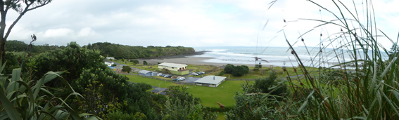
Opunake Beach The Riviera of South Taranaki is an outstanding, natural surf attraction that draws visitors and surfers from all over the world. A holiday park and playground are available. The beach was also recently upgraded to offer barbecues and picnic sites for everyone’s use.
The Lion’s Lookout The lookout is located next to the ramp by the old wharf and offers clear views of the Taranaki Bight.
Middleton Bay has a boat ramp for easy launching, though it is not a safe swimming beach.
Te Namu Pa The pa is visible from the northern end of the walkway and is an extremely important site in Taranaki.
It was the location of a famous battle where Wiremu Kingi Matakatea repelled 800 Waikato Maori and successfully withstood a month-long siege armed with a single rifle.
The best access to the site is via Opunake Cemetery and then over the Otahi Stream. Te Namu Pa is on private property and the owners and the Historic Places Trust ask that the area be treated with care and respect. There are open food storage pits and tunnels on the site and these can be dangerous.
There are comprehensive maps for your information at either end of the walk.

Te Henui Extension

By North Island, Taranaki Walks

Te Henui extension  a rustic and interesting stroll

Popular New Plymouth walk by Judy Eva

The popular award winning Te Henui Walk/Cycleway which starts at East End Beach, New Plymouth and follows the Te Henui River exiting in  Cumberland Street, has an extension probably not well known to visitors.

It carries on across Cumberland Street and through a rustic and interesting stroll.

If you have started the walk from the east end and exited at Cumberland Street turn right onto the footpath, over the road bridge and cross Cumberland Street to the grass area where there is a New Plymouth District Council signpost just off the footpath titled Te Henui Extension and Durham Avenue each with an arrow pointing to the start of the walk. These are the arrows you need to follow. The track starts at the rear of the grassy area.

The extension walk is very different to the main Te Henui Walk/Cycleway (not suitable for bikes) and is broken into different area’s which involves walking through several streets and can be quite confusing, however is worth making the effort.

The track is more narrow but well maintained. It starts off with a pleasant rustic walk, the river on your left side and a view down into a valley that has a grotto of punga trees and ferns. There are several little wooden bridges along the way.

There are several signposts on the right side of the track that take you up to the road above, leads to several streets and is the main road to Inglewood. Not for you.

Keep following the main track (river on your left) until you come to about 12 steps with a forked path at the top leading left and right. Keep left and follow the signpost that says Durham Avenue continuing around through an open space where you will come to a bush area with steps leading down into a tree covered dell and over a small wooden bridge before climbing up stairs to the top again.

When you reach the top veer right and take the short narrow path that leads between fenced houses on either side ending out onto the top end of Durham Avenue which is a cul de sac.

Cross over onto the left side of the street and walk down to the bottom where you will be in Junction Street. Turn left and then left again at the next corner which is London Terrace. A short way along there is a lane on the right hand side of the road leading up a hill with a sign at the entrance stating Access to Heta Road.

Walk up the lane turning right at the top (there are houses on either side) and follow the lane to the end where there is a walkway exit on the right that takes you onto Heta Road. At this point if you do not wish to continue the walk, turn left on Heta Road walk to the bottom of the hill and you will be back in Cumberland Street. If you wish to continue the walk cross Heta Road turn right and then left into a small cul de sac further along called Frank Frethey Place.

Cross over onto the right hand side of Frank Frethey Place, walk a short distance along and you will see a grass lane entrance between number 10 and number 12. Take this entrance where there are steps leading down to another tree and bush covered dell.

Another lot of steep steps to climb up again and the track will then take you out into an open space where there is a fork, one leading into a street and housing area and the other turning left down a hill. Take the left and you will be walking on a gravel path alongside a large timber and corrugated iron fence on your right and a ditch on your left.

As you walk further on there will be houses on either side and the ditch will now be on your right. This area is new housing.

This path will eventually lead you through another short tree lined track and out onto the bottom of Heta Road where the walk finishes.

Turn the right and a short distance takes you back onto Cumberland Street, turn left there, cross the road and you will be back at the entrance to the main Te Henui Walkway that leads back to East End Beach. If the road is busy with traffic there is an underpass you can use.

If you don’t wish to do the complete walk starting at East End you can start the extension walk from Cumberland Street where you can park your car if you have one. The entrance to both walkways is at the bottom of the hill in Cumberland Street. Plenty of parking there.

The extension walk is easy walking and the steep stairs up and down in both dells are the only challenging part. You need good walking shoes. This walk would be about an hour to an hour and a half from the Cumberland Street entrance.