All Posts By

Frank

Queen Charlotte Track

By Marlborough Walks, South Island, Walking Tours etc

Queen Charlotte Track . . . Here we come!

By Juliet Gibbons

We’re all going on a summer holiday
No more working for a week or two.
Fun and laughter on our summer holiday,
No more worries for me or you,
For a week or two.

We’re going where the sun shines brightly
We’re going where the sea is blue.
We’ve all seen it on the movies,
Now let’s see if it’s true.

They say that a change is as good as a holiday and if COVID-19 has taught us anything at all, it’s that change can remind us of what is important in life. Family, friends, good times, fun in the sun and laughter. And, of course, the importance of being kind.
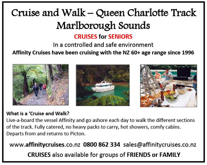
The operators behind the Queen Charlotte Track in the Marlborough Sounds know something about most of these things, fun in the sun being one of them! Located in one of the sunniest regions in New Zealand, the great summer climate is one of the attractions they are keen to encourage New Zealanders to come and experience for themselves this coming summer.
There’s also history here too. The Queen Charlotte Track offers a spectacular 72km hike from the historic Meretoto/Ship Cove through to picturesque Anakiwa. Ship Cove is a place that features high on the list of most iconic historic places for New Zealanders to visit as it was here the first sustained contact between the New Zealand Maori and the European took place.
This came to national prominence earlier this year as New Zealand commemorated 250 years since the arrival of Captain James Cook in what became the precursor to European settlement in New Zealand.
Meretoto/Ship Cove was the epicentre of English navigator Captain James Cook’s explorations in the South Pacific – a snug cove in the outer Queen Charlotte Sound where he replenished water supplies, rested his men and repaired his ships on five different visits between 1770 and 1777. British sovereignty was first proclaimed by Cook over the South Island when the British flag was formally raised on the summit of Motuara Island, opposite Ship Cove, on 31st January 1770.
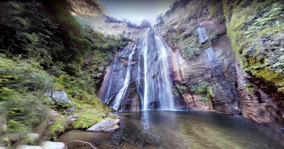
As well as its historical connections, the Queen Charlotte Track is a truly unique New Zealand walk due to its variety of landscapes as the well-defined track passes through lush coastal forest, meanders around tranquil bays and traverses skyline ridges affording unsurpassed views of the Queen Charlotte and Kenepuru Sounds.
The terrain is regarded as undulating with hills ranging from sea level to just over 400 metres and most of the track is wide and benched which makes for a pleasant stroll. The trail crosses a mixture of public and private land, a unique partnership between the Department of Conservation, QCTLC (Queen Charlotte Track Land Co-operative) and Marlborough District Council, and visitors are required to have purchased the appropriate pass if crossing the private land sections.
You will find real New Zealand here – where friendly locals welcome you to their door, your bags are transferred each day and the access is easy while you adventure. This is a walking track where you can create memories in your own style and at a budget that suits your wallet.
The track can be walked year-round thanks to that great Marlborough Sounds’ climate with the most popular season being from November to May. It is also a popular trail for mountain bikers with some sections open all year to enjoy. The majority of visitors access the track by boat from the port of Picton but day walks are available where the road meets the track such as at Anakiwa, Torea Bay and Te Mahia Saddle.
You can camp at Department of Conservation campsites, private campsites and farm stays, or opt for accommodation in backpackers, home stays, bed and breakfasts, retreats and lodges or hotels along the way all while taking advantage of the water transport services which allow your luggage to be transferred each day.
Cook for yourself or take the night off, if staying at or near accommodation with restaurants. Many of the smaller lodges offer catering options too.
For those with a little more time, or seeking something a little different, there are many other activities that can be enjoyed along the way. These include swimming, fishing, sailing, sea kayaking, bird and dolphin watching, diving and historic side trips. Glow-worm grottos add to the nightlife.
There are guided and unguided packaged walking options available too and both can have their packs carried for them from any of the access points along the track by arrangement with transport operators. The sheer pleasure of arriving or departing the track by sea adds to the experience and with its historic interest and many comfortable accommodation houses along the way serving good food and wine, it could easily be called the ‘gourmet’s trail’.
Come and experience the breathtaking ridge top panoramas of Queen Charlotte and Kenepuru Sounds and enjoy the company of friendly hosts and superb food and wine. For more information on how to book your ‘summer holiday’ see the official track website at www.qctrack.co.nz

The Queen Charlotte Track – Why Walk When You Can Ride?

The Queen Charlotte Track is one of New Zealand’s best-loved walking trails, but it is also a popular destination for mountain bikers as one of New Zealand’s Great Rides on the Ngā Haerenga New Zealand Cycle Trail.
It offers a unique combination of beautiful coastal scenery, native bush, stunning views and New Zealand history. The natural appeals are complimented by easy access, an outstanding choice of hosted accommodation, pack transfers and a wide variety of flexible options for day or multiday trips, including all-inclusive packages from local providers. It offers bikers an exhilarating and challenging experience over 72km and is able to be biked comfortably in three days.
The Queen Charlotte Track has long been regarded as one of the best single tracks in the country. The track is graded as advanced/grade 4 for mountain biking although some sections are easier than others and lend themselves to day rides for those not wanting to attempt the entire track. The demographic of those riding the track is also changing as biking grows in popularity amongst older age groups.
Most riders will find some sections of the track easier to walk and you will likely need to push your bike in certain parts. If you are fit and experienced at mountain biking, most of the track is very rideable, albeit steep and challenging in certain sections, especially when rain has rendered it slippery and muddy. Less experienced riders may prefer to avoid the ridge-top sections of the central part of the track by riding along Kenepuru Road between Kenepuru Saddle and Portage Bay, still enjoying wonderful Sounds views.
The Marlborough Sounds is an iconic New Zealand destination – an intricate land mass, making up one fifth of New Zealand’s coastline, of numerous bays and coves caused by the drowning of river valleys by rising oceans over the past 10,000 years.
It is through this awe-inspiring landscape bikers can test themselves against a trail which takes them from shoreline to skyline, through magnificent virgin native forest at the track’s start at Meretoto/Ship Cove as well as regenerating forest and farmland along the rest of its length. Mountain biking is one of the best ways to explore this stunning area and learn about its fascinating history.
Although challenging in parts, the Queen Charlotte Track experience is made all the easier with the thought of comfortable lodgings awaiting each evening from backpackers through to lodges and even hotels. And the best part is your pack is transferred for you between your night time stays, by one of the water transport operators, so all you have to do is ride.
Important Footnote: You can bike the whole track from Ship Cove to Anakiwa between 1 March and 30 November each year. From 1 December to the end of February, the track is open for mountain biking between Kenepuru Saddle and Anakiwa. As the track is a shared use track and popular with walkers, you will need to ride in control and be prepared for walkers around each corner. Riding in the same direction as most others, from Ship Cove to Anakiwa is advised. For more information visit www.qctrack.co.nz

Walking the Talk
Queen Charlotte Track Inc. has championed the virtues of the Queen Charlotte Track since 1993 and COVID-19 is a challenge the organisation is ready to meet and overcome.
Chairman Rob Burn is set to ‘walk the talk’ of supporting local when he and his wife Carolyn retrace the steps she last walked 25 years ago, completing most of the Queen Charlotte Track this winter.
“I have promised Carolyn a walk on the Queen Charlotte Track the first chance we get, seeing our own backyard, especially with our Autumn weather still good,” he says.
“Most of our operator members have not had an easy time over the last few months and without international flights our tourism businesses will likely just be welcoming our fellow Kiwis who we hope will explore our local offerings to get us through this coming Winter and Summer,” he says.
Rob and his wider committee are motivated to ensure New Zealanders are aware of the wonderful experience the Queen Charlotte Track offers.
“Our other ray of sunshine could be the ‘Trans-Tasman Bubble’ concept being worked on now. We all know our Aussie cousins and expat Kiwis love to walk, cycle, eat and drink and that is what the Queen Charlotte Track can offer in abundance,” he says.
So fellow New Zealanders, there has never been a better time to follow in Rob’s footsteps, to support local New Zealand walking trails like the Queen Charlotte Track and venture out into your big backyard.

What are you waiting for New Zealand?

Pukerua Bay to Plimmerton

By North Island, Wellington Walks

Wednesday Trampers go to the Seaside

Words by Ian Brookes, Photos by William

In November, 18 intrepid Wednesday trampers and a small dog left Memorial Park at 7.30am for their annual trip to the beach at Pukerua Bay north of Wellington.

On our way south, the weather looked rather threatening, with low cloud over the Tararua Ranges (using the terminology recommended in Backcountry), but clearer out to sea. We assembled at the end of the Pukerua Bay Beach Road to walk round the Wairaka Headland to Plimmerton and return via the inland route.

There was a chilly breeze from the West as we set off, but this dropped once we rounded Wairaka Head and the weather from thereon was fine and sunny.

The path is flanked by steep grassy slopes on which a number of feral goats were seen grazing. We soon reached a strategically placed wooden gate leaning against the rocks which is easily climbed and then after a scramble round the  headland made it on to a long sweep of beach. This consists of large pebbles and small boulders, which need care in negotiating.

On the way, we encountered a small dead blue penguin washed up on the beach. There is plenty of driftwood at the high tide mark, and after an hour’s walking we chose to sit on some largish logs for morning tea.

The beach eventually leads to a further half hour’s walking on a gravel track heading towards Plimmerton. While on the track, we encountered a walker with two large dogs. An attempt to get them onto leads was only partially successful and one of them charged towards one of our trampers, but no damage was done.

Having passed through the Hongoeka Marae Village, we reached the boating club, where four of our number decided to head into Plimmerton and take the train back to Pukerua Bay.

The rest of us continued into the Karehana Bay Scenic Reserve, where we had lunch at the bottom of a long and steep flight of steps. These provided a challenge immediately after lunch, but the party all reached the top, albeit somewhat puffed.

We then headed up the Taua Tapu Track passing alpacas and donkeys on lifestyle blocks. The track reaches a trig at 114 metres and then descends to Airlie Road. We followed this past the Whenua Tapu Crematorium until we reached the Ara Harakeke walkway which runs parallel to SH1. This winds uphill for about two kilometres to the Pukerua Bay shops. Walking on the asphalt left some trampers in need of refreshment and it was disappointing to find the dairy’s ice cream chiller had lost power.

Another 20 minutes along Rawhiti Road led to the Goat Track, which descends by a number of steep steps down to the beach. Everyone was back to the vehicles by 2.15pm to find the train travellers had arrived safely before us. We then reconvened for coffee and ice creams in Paekakariki.

It was generally agreed that this was the preferred route, rather than that in previous years, when we went inland first. Doing it this way meant the rocky beach was tackled at the start of the day, even though the finish involved the rather tedious walk up the shared cycle path. The statistics collected at the end of the day showed we had walked a distance of almost 17 kilometers.

Te Henui Extension

By North Island, Taranaki Walks

Te Henui extension  a rustic and interesting stroll

Popular New Plymouth walk by Judy Eva

The popular award winning Te Henui Walk/Cycleway which starts at East End Beach, New Plymouth and follows the Te Henui River exiting in  Cumberland Street, has an extension probably not well known to visitors.

It carries on across Cumberland Street and through a rustic and interesting stroll.

If you have started the walk from the east end and exited at Cumberland Street turn right onto the footpath, over the road bridge and cross Cumberland Street to the grass area where there is a New Plymouth District Council signpost just off the footpath titled Te Henui Extension and Durham Avenue each with an arrow pointing to the start of the walk. These are the arrows you need to follow. The track starts at the rear of the grassy area.

The extension walk is very different to the main Te Henui Walk/Cycleway (not suitable for bikes) and is broken into different area’s which involves walking through several streets and can be quite confusing, however is worth making the effort.

The track is more narrow but well maintained. It starts off with a pleasant rustic walk, the river on your left side and a view down into a valley that has a grotto of punga trees and ferns. There are several little wooden bridges along the way.

There are several signposts on the right side of the track that take you up to the road above, leads to several streets and is the main road to Inglewood. Not for you.

Keep following the main track (river on your left) until you come to about 12 steps with a forked path at the top leading left and right. Keep left and follow the signpost that says Durham Avenue continuing around through an open space where you will come to a bush area with steps leading down into a tree covered dell and over a small wooden bridge before climbing up stairs to the top again.

When you reach the top veer right and take the short narrow path that leads between fenced houses on either side ending out onto the top end of Durham Avenue which is a cul de sac.

Cross over onto the left side of the street and walk down to the bottom where you will be in Junction Street. Turn left and then left again at the next corner which is London Terrace. A short way along there is a lane on the right hand side of the road leading up a hill with a sign at the entrance stating Access to Heta Road.

Walk up the lane turning right at the top (there are houses on either side) and follow the lane to the end where there is a walkway exit on the right that takes you onto Heta Road. At this point if you do not wish to continue the walk, turn left on Heta Road walk to the bottom of the hill and you will be back in Cumberland Street. If you wish to continue the walk cross Heta Road turn right and then left into a small cul de sac further along called Frank Frethey Place.

Cross over onto the right hand side of Frank Frethey Place, walk a short distance along and you will see a grass lane entrance between number 10 and number 12. Take this entrance where there are steps leading down to another tree and bush covered dell.

Another lot of steep steps to climb up again and the track will then take you out into an open space where there is a fork, one leading into a street and housing area and the other turning left down a hill. Take the left and you will be walking on a gravel path alongside a large timber and corrugated iron fence on your right and a ditch on your left.

As you walk further on there will be houses on either side and the ditch will now be on your right. This area is new housing.

This path will eventually lead you through another short tree lined track and out onto the bottom of Heta Road where the walk finishes.

Turn the right and a short distance takes you back onto Cumberland Street, turn left there, cross the road and you will be back at the entrance to the main Te Henui Walkway that leads back to East End Beach. If the road is busy with traffic there is an underpass you can use.

If you don’t wish to do the complete walk starting at East End you can start the extension walk from Cumberland Street where you can park your car if you have one. The entrance to both walkways is at the bottom of the hill in Cumberland Street. Plenty of parking there.

The extension walk is easy walking and the steep stairs up and down in both dells are the only challenging part. You need good walking shoes. This walk would be about an hour to an hour and a half from the Cumberland Street entrance.

Shine Falls walks

By Hawke's Bay Walks, North Island

Rising 58 metres, Shine Falls is Hawke’s Bay’s most spectacular waterfall.

Shine Falls is roughly a 1.5 hours drive away from Napier, and the last 12km is gravel road – but it’s worth the trip!
The Shine Falls track is a 1.5 hour return walk, and leads to the base of the waterfall. The walk passes through farmland and beneath towering sandstone bluffs. There are some uphill sections on the track as well as stream crossings, but they are all bridged and easy. Low-land forest includes kanuka, kawakawa, kowhai and titoki.

Getting there
From Napier, head north-east on SH2 and follow it for the next 43.5km until you see the ‘Shine Falls’ sign, where you need to turn left into Matahorua Rd. After 11km turn left into Heays Access Rd. Follow this road for 6.5 km until you reach a DOC car park, on your left, with a picnic table (no toilets).

Kamahi Loop Track to Shine Falls and Heays Accesss Road

The Kamahi Loop Track is another but longer walk taking in Shine Falls in Hawkes Bay.
The walk time is five hours one way over a distance of 8.3km.
Starting at the Pohokura Road car park and taking in part of the Tūmanako and Kamahi loops, visitors experience a cross-section of the reserve’s features – including an ancient mataī about 800 years old and birds such as tītitipounamu/rifleman and the reintroduced pītoitoi/North Island robin.
Middle Track, between the midpoint of Kamahi Loop and Shine Falls, may be steep and rough in some sections.
From above Shine Falls, the track descends steeply through stands of rewarewa, crossing Boundary Stream to reach the bottom of the spectacular Shine Falls before continuing to Heays Access Road.

Getting there
Boundary Stream Mainland Island is located approximately one hour’s drive north of Napier.
Follow State Highway 2 to Tutira, turn left at Tutira onto Matahorua Road then left onto Pohokura Road.

Tarawera – a legacy to uphold

By North Island, Rotorua Walks

Lake Tarawera area for great nature walks

Lake Tarawera including Lake Rotomahana was were tourism in New Zealand started.

People came from all over the world to visit what was known as the Eighth Wonder of the World, The Pink and White Terraces. They not only came for the beauty the Terraces beheld, but in those days, many were looking for relief or hopefully a cure from their ailments by bathing in the pools of the Terraces.
Well, that all changed on the 10th of June 1886 with the eruption of Mt Tarawera, an event that lasted only five hours. I n doing so it split the mountain open its entire length, continued through the hydrothermal of Lake Rotomahana with a fissure of more than 17km.
What nature had created over a 1000 years; it had also decimated in the blink of an eye. The Terraces were gone. The eruption was the largest natural disaster to have occurred in the commonwealth up until that time.
Forward 134 years to the present day and Lake Tarawera and the surrounding area has once again become one of the most stunning places of natural beauty in New Zealand.
Large clusters of pohutukawa, mamaku and rewarewa surround the lake, right down to its waters edge with housing taking in only a small portion on one side of the lake.
The backdrop to Lake Tarawera is still dominated by the awesome presence of Mount Tarawera itself. More correctly Tarawera is made up of three mountains, from the left, Wahanga (the sacred mountain), Ruawahia in the centre and Tarawera being the right-hand side. Up until around 20 years ago people freely walked Tarawera, but this was halted by the Ngati Rangitihi mountain top owners.
In 2013 the Tarawera Trail was opened. This was a first in New Zealand as a joint project between DOC and six Maori block owners which the trail now crosses. The trail itself is 15km long starting at the Te Waiora – Tarawera Trail car park 400m south of the Buried Village.
It takes an average of four to five hours to walk to Hot Water Beach for moderate walkers which is the end point of the trail. There are many highlights along the mostly bush covered walk that make it pretty special, finishing with a soak in the thermal waters at Hot Water Beach after your walk.
There are many beautiful viewing spots of Mt Tarawera and a couple of great beaches for lake swimming or a lunch-stop along the way.
There is the option to camp at the Hot Water Beach DOC campsite at the end of your walk or take the water taxi back including the free shuttle back to your car.  If you decide to camp you can get the water taxi to deliver your gear to save you having to carrying it in. You do need to pre-book your campsite on www.whakarewarewa.com. If you would like a glamourous camping option for a couple of nights you could book to stay at the Totally Tarawera glamping site which could include your dinner and breakfast hamper.  View this on www.totallytarawera.com.
One of the lesser known walks at Lake Tarawera, although rated by DOC as one of the best short walks in New Zealand, is the Tarawera Falls walk.  Accessed via Kawereu, after obtaining a permit from the local Kawereu I-site, it allows you to drive the forest road to within 15 minutes of the falls themselves or you can organise a water taxi to drop you off at the Outlet (Te Tapahoro) for the one and a half hour walk to the falls. The falls are spectacular, but the walk to and from the lake is equally stunning as you follow the river down from Lake Tarawera. There are three additional waterfalls along the walk, and if you look carefully you will see where the water disappears underground prior to it emerging through a hole in the cliff, that makes up the Tarawera Falls themselves.
There are several other combination walks around Lake Tarawera, one being via Lake Okataina to Humpheries Bay and on to the Outlet, a walk of around five hours. From there you can stay at Te Tapahoro DOC campsite for the night or catch the water taxi out to the Landing.  Added to that could be a walk from Lake Okeraka along the Western Okataina, then eastern Okataina walkway ending up at the Outlet a walk best taken over two days. Camping is an option at Humpheries Bay and at the Outlet.
Totally Tarawera is a family business at Lake Tarawera that links back to the Maori tribal guides who hosted and took care of international visitors across Lake Tarawera to The Pink and White Terraces. This family legacy continues on the lake today where they provide water taxi service, guided cultural tours, glamping and lake cruises.
Karen says It is about manaaki, caring for our visitors and ensuring they have a memorable experiences with us.  A legacy that has with stood over 150 years.

Spoilt for choice in Wellington

By North Island, Wellington Walks

Lots of amazing walks in our Capital city

By Judith Doyle

For a capital city with an ever-increasing population, Wellington has an amazing choice of walks, even close to the city. From my home in the city suburb of Oriental Bay, I can decide on a waterfront wander, east or west; a bush and hillside walk; a climb to the top of Mt Victoria or a stroll along suburban roads with flashes of water between the houses.

Downhill at the seafront I have two choices. Go east and watch the dogs on the beach in winter, the swimmers and sunbathers in high summer and all the variations of weather and people at other times.

The road follows the curve of the beach until it reaches Point Jerningham where I can round the point and walk on to the cosy little curve of Balaena Bay. Here I often see windsurfers skipping across Evans Bay like syncopated butterflies.

If I choose to turn west at the seafront, I pass the whale statue (pictured) which was donated to the city by its sculptor Colin Webster-Watson.

Further on, I watch the children playing on the jungle-gym where a small boy always seems to be climbing up the slide and colliding with a child sliding down.

Past the Tugboat café moored in its own the little lagoon, I like to drop down from the footpath and walk along the edge of the water past the blue-fronted boatsheds, enjoying the variety of craft in the lagoon and occasionally peering into any boatshed that’s open to see the conglomeration of sailing equipment inside.

Up and past Clyde Quay with its classy restaurant and apartments, I walk towards the city past the statue (pictured) of a naked man by English sculptor Max Patte. Called Solace in the Wind, it leans out towards the harbour and is a favorite spot for tourist photos. It was donated to the city 11 years ago by its Patte, originally as a parting gift to a city he had worked in and enjoyed. But  later he found he’d enjoyed it so much that, in fact, he decided to stay.

If I decide to turn uphill from my home instead of downhill, then the whole Town Belt is at my disposal. I walk up a zigzag pathway that leads to the Monastery where I can turn left and later right to reach Charles Plimmer Park and then the variety of tracks in the Town Belt. Here are bushy tracks that even the sharpest Wellington winds cannot penetrate.

If I take one direction, I look down over Oriental Bay or up into the bush with its half-hidden houses. I then have a choice of tracks leading back down to the beach. Other tracks can be taken to the top of Mt Victoria (my energy doesn’t stretch to that walk very often these days) or along towards Newtown where I can walk through bush. Occasionally gaps in the bush allow me to gaze across towards the Basin Reserve.

For the growing numbers living in apartments, which will increase in future years according to current estimates, these walks and many others near the city are of enormous value.

We are so lucky that, in early days, a Town Belt of trees was reserved to encircle the city. Although a few ‘bites’ were taken out of it occasionally in the past, it is now protected legally and is sancrosant. The Town Belt and the tracks within it are a precious heritage and must be diligently protected forever.

Saunter back in the 1930’s

By Hawke's Bay Walks, North Island

Judith Doyle explores Napier’s past

The 1½ hour Art Deco walk in Napier is more a saunter than a walk. It has to be, because every few metres during the 1.2km walk there’s another zig-zag, sunburst or ziggurat to look at. And they are often at neck-cricking level.

There’s two ways to explore Napier’s past. You can pick up a self-guided map and make your own way around. Or, like our group of 10, you can choose to join a guided walk.
It was way back in 1985 when a leaflet called Take a Walk through Art Deco Napier started the tradition.
It had been published by a group who were keen to preserve Napier’s 1930s buildings which had gone up after the earthquake when the Art Deco, Spanish Mission and (a bit later) the Moderne style of architecture was in vogue.
More than a thousand people turned out for the walk. This enthusiastic response from the public encouraged the founding of the Art Deco Trust which has gone from strength to strength ever since.
Our walk starts at their base in the Art Deco Centre, Tennyson Street. The building was designed by Louis Hay in 1932 — an architect who put his stamp on many buildings that we follow on the walk.
Nicky, our guide, has been a volunteer for seven years — one of 120 volunteers
She takes us along Herschell Street (past a seated figure) where we pause at the newly-restored entrance to the Museum Theatre Gallery Hawke’s Bay. This is the original entrance from the 1930s (not used on a daily basis). The exterior of this Art Deco building looks much the same as when it was built but it has been subtly modernised inside so that light floods in.
Further along the street is the brick façade of Louis Hay’s own office, built in 1932. It was most unusual to use bricks then, as brick had performed so badly in the earthquake. But Hay’s brickwork was a veneer over reinforced concrete.
Soon we’re in Hastings Street with three Hay buildings. We pick out the typical Art Deco flourishes like the ziggurat motifs and the  ‘eyebrows’ (American architect Frank Lloyd Wright was an influence here).
At the end of the street we look across at the strong vertical lines of another Hay building — the AMP. The inner glass entrance doors and their hardware, discovered recently in private ownership, have been returned and re-installed.
We walk along Tennyson Street and look at a string of 1930s buildings, built by different architects. The Daily Telegraph building (E.A.Williams, 1932) is full-on Art Deco — zig-zags, fountain shapes, ziggurats and a sunburst. The paper merged with the Hastings paper to become Hawke’s Bay Today but luckily a far-seeing businessman bought the building and restored it to its former glory.
Neighbouring buildings are by Finch and Westerholm (the most prolific of the reconstruction architects), Natusch with Hay, and Gummer Architects of Auckland. Built a few years later, by J.T Watson borough architect, is the stunning Municipal Theatre (1938) which epitomises the streamlined ‘moderne’ style with chrome speed lines, nautical light fittings, neon and tubular lamps.
As in a few other buildings, there’s an Egyptian feel to the decoration in the Municipal Theatre — the discovery of Tutankahmen’s tomb had unleashed an enthusiasm for ancient cultures.
We’re soon walking up Emerson Street where Kidsons Building has zigzag friezes and quirky windows; Briasco’s has leadlight glazing; a good example of overlapping rectangles is seen on a Hay building and the Hawke’s Bay Chambers has the lot — symmetry, ziggurats, herringbone glazing bars and a jazzy monogram.
And so the walk progresses. We weave in and out of the streets in central Napier, noting the Spanish Mission style of the Criterion Hotel and the amazing Maori Kowhai patterns on the ceiling of the ASB Bank.
At the end of the walk I find myself beside the street statue of the trendy young woman with her equally elegant dog. Luckily there’s one of Napier’s attractive cafés there too where we can relax over a coffee — resting the feet and de-cricking the neck.

Seaview Gardens – Foxton

By Manawatu Walks, North Island, Short Walks

A short walk in Foxton town

Seaview Gardens Reserve is an historic, elevated garden at the south end of Foxton’s Main Street, in the Horowhenua, that offers a  short walk up a hill.

The gardens contain native trees in a hilltop park, with extensive views of the surrounding town and rural areas.
This area up and around the water tower was once called Ferry Hill.
People used to walk up the hill to watch the ferries go across the river below and to watch the ships enter the river entrance at the Manawatu Heads (Foxton Beach).
The ferry enabled travellers and the Wellington-Wanganui stage coach to cross the river to Foxton after travelling up the coast. Ferry Hill became Seaview Hill and with the planting of the gardens, became Seaview Gardens.
In the 1930s the gardens included terraces, plantings, fish ponds, ponga shelters and a bird aviary.
Following a cutback in Borough spending in the 1950s, the gardens have gradually “disappeared”, until recently the council have constructed the walking tracks and planted flax and placed signs.
The water tower was constructed in 1923 and still provides pressurised water distribution for Foxton and is now also used for a mobile phone tower.

Te Puna Quarry Park Garden

By Bay of Plenty Walks, North Island, Short Walks

By Judith Simpson
My favourite short walk has always been “Around the Mount” but we’ve discovered Tauranga’s Hidden Secret. The Te Puna Quarry Park Garden.
Perhaps you need to be a little more energetic to do this walk but it’s definitely worth the effort. It’s really a treasure, full of unexpected joys.
Some people run around the main track in 20 minutes, others take all morning to investigate the side tracks that lead to all sorts of adventures for young and old.
It’s a place to take your granny for a stroll along the lower level to smell the flowers in the raised garden for the blind or to just take a rest under the flowering cherries and watch the children clamber over the enormous stone dragon or slide down the silver slide from the princess’s castle.
Take your grandchildren and let them clamber into the big digger and pretend they’re in control of filling the next lorry with gravel. They may want to climb up through the Rhododendrons and Vireyas to make music on the pipes and gongs or walk a little further to ride on a big wooden engine complete with guard and flag while you sit on a bench and admire the view.
82 acres of wilderness.
Making it into a community resource was the vision of a local lady, Shirley Sparks. With a group of willing volunteers they began cutting and hacking their way through the gorse and rubbish. They met every Tuesday morning and still do today to weed, clear and plant, turning it into a parkland.
It was opened in 2000 by the Governor General Sir Michael Hardie Boyes.
The quarry had been abandoned and over time it had become a dumping ground for any old waste, fridges, washing machines, you name it. Most of the area was quite dangerous. Today it is hard to imagine what it must have been like for those early volunteer battling  four metre high gorse and scrub.
But let’s take walk up the main track. This isn’t a garden parkland for the purists. There’s been no grand design and as groups have offered time so the garden has developed. Old Heritage Roses, the Fuchsia group, a native area, Bromeliads and a Japanese Garden with Bonsais to name a few have all organised their chosen spaces.
A family giving up as Orchid growers donated a trailer load of roots to make an unrivalled display as you walk up the track.
Take a diversion to investigate the Monarch Butterfly House.
Swan plants reign supreme and butterflies flutter everywhere. If your caterpillars are being eaten by wasps? You can bring them up to Mary who will pop them in the purpose built House to “chrysalis” in peace. And then be released as butterflies.
Onwards to the first terrace and “Brian’s Wall”. A dry stone wall built by his family in his memory and as a lasting gift to the community.
You can lean on the wall and gaze down on the butterflies and Fuchsias or out over the Bay to Omokoroa, Matakana Island and the Mount. Stunning. It’s a wonderful place to show visitors what Kiwifruit orchards look like from above with their tall, thin shelterbelts or just the green, luscious looking Te Puna landscape.
All along the way you stumble across “treasures”. A mosaic set in the pathway below the abseiling cliff wall, a cairn that reminds you of Nepal, corrugated cut-outs of bushmen and you often see groups having their photo taken with the life-sized mosaic family enjoying afternoon tea.
Up the “Lions’” stone steps. What labour went into creating these enabling a round walk to be developed. The Lions also planted a grove of Kauri trees and the local Rotary was involved in pond making and getting the old water wheel into working order. It really is a community project.
As you come off the Lions’ steps you look out over a valley covered in Ponga ferns – a sea of waving, green umbrellas? And then it’s down wooden steps to an area newly planted in Magnolias. What a sight they will be in a year or two.
Shirley and her committee have thought of many ways to be useful to the community.
Want to have a wedding? There’s a pavilion complete with small kitchen that can be yours for a donation and many’s the time we’ve seen birthday celebrations on the green lawn, a Book Club having a summer picnic lunch and their monthly meeting or our group having fish and chips under the cherry trees.
But there’s more if you have time. A hidden path behind the Pavilion follows a small stream up to a waterfall. This part is still untamed and if you’re lucky you may hear a Bellbird sing or see a Wood Pigeon lumber overhead and of course there are tuis all around.
Our Quarry is an amazing place with something for everyone to enjoy. It is my favourite place. Why don’t you come and visit our Te Puna treasure sometime soon?

Anzac Park Scenic Reserve

By Hawke's Bay Walks, North Island, Short Walks

Anzac Park Scenic Reserve is a sheltered pocket of native forest, located 3km north of Norsewood in Central Hawkes Bay just a few metres off State Highway  2.
This is a pleasant place for travellers to have a short or overnight stopover and have a short stroll.
On looking further up the park there is a short forest walk about 500 metres, starting with a formed track and later just marked with arrows.
One is unlikely to get lost as it is a banana shaped belt of trees. It is just a great place to stop and stretch the legs after a long journey. Matai and totara are prominent and there is a wealth of smaller broad leaved trees.
A large grassed area adjacent to the forest is set aside for picnicking and camping with a picnic shelter, toilets, water supply and barbecue facilities provided.
Over nighters are expected to pay a small charge towards facility maintenance.