Category

North Island

Saunter back in the 1930’s

By Hawke's Bay Walks, North Island

Judith Doyle explores Napier’s past

The 1½ hour Art Deco walk in Napier is more a saunter than a walk. It has to be, because every few metres during the 1.2km walk there’s another zig-zag, sunburst or ziggurat to look at. And they are often at neck-cricking level.

There’s two ways to explore Napier’s past. You can pick up a self-guided map and make your own way around. Or, like our group of 10, you can choose to join a guided walk.
It was way back in 1985 when a leaflet called Take a Walk through Art Deco Napier started the tradition.
It had been published by a group who were keen to preserve Napier’s 1930s buildings which had gone up after the earthquake when the Art Deco, Spanish Mission and (a bit later) the Moderne style of architecture was in vogue.
More than a thousand people turned out for the walk. This enthusiastic response from the public encouraged the founding of the Art Deco Trust which has gone from strength to strength ever since.
Our walk starts at their base in the Art Deco Centre, Tennyson Street. The building was designed by Louis Hay in 1932 — an architect who put his stamp on many buildings that we follow on the walk.
Nicky, our guide, has been a volunteer for seven years — one of 120 volunteers
She takes us along Herschell Street (past a seated figure) where we pause at the newly-restored entrance to the Museum Theatre Gallery Hawke’s Bay. This is the original entrance from the 1930s (not used on a daily basis). The exterior of this Art Deco building looks much the same as when it was built but it has been subtly modernised inside so that light floods in.
Further along the street is the brick façade of Louis Hay’s own office, built in 1932. It was most unusual to use bricks then, as brick had performed so badly in the earthquake. But Hay’s brickwork was a veneer over reinforced concrete.
Soon we’re in Hastings Street with three Hay buildings. We pick out the typical Art Deco flourishes like the ziggurat motifs and the  ‘eyebrows’ (American architect Frank Lloyd Wright was an influence here).
At the end of the street we look across at the strong vertical lines of another Hay building — the AMP. The inner glass entrance doors and their hardware, discovered recently in private ownership, have been returned and re-installed.
We walk along Tennyson Street and look at a string of 1930s buildings, built by different architects. The Daily Telegraph building (E.A.Williams, 1932) is full-on Art Deco — zig-zags, fountain shapes, ziggurats and a sunburst. The paper merged with the Hastings paper to become Hawke’s Bay Today but luckily a far-seeing businessman bought the building and restored it to its former glory.
Neighbouring buildings are by Finch and Westerholm (the most prolific of the reconstruction architects), Natusch with Hay, and Gummer Architects of Auckland. Built a few years later, by J.T Watson borough architect, is the stunning Municipal Theatre (1938) which epitomises the streamlined ‘moderne’ style with chrome speed lines, nautical light fittings, neon and tubular lamps.
As in a few other buildings, there’s an Egyptian feel to the decoration in the Municipal Theatre — the discovery of Tutankahmen’s tomb had unleashed an enthusiasm for ancient cultures.
We’re soon walking up Emerson Street where Kidsons Building has zigzag friezes and quirky windows; Briasco’s has leadlight glazing; a good example of overlapping rectangles is seen on a Hay building and the Hawke’s Bay Chambers has the lot — symmetry, ziggurats, herringbone glazing bars and a jazzy monogram.
And so the walk progresses. We weave in and out of the streets in central Napier, noting the Spanish Mission style of the Criterion Hotel and the amazing Maori Kowhai patterns on the ceiling of the ASB Bank.
At the end of the walk I find myself beside the street statue of the trendy young woman with her equally elegant dog. Luckily there’s one of Napier’s attractive cafés there too where we can relax over a coffee — resting the feet and de-cricking the neck.

Seaview Gardens – Foxton

By Manawatu Walks, North Island, Short Walks

A short walk in Foxton town

Seaview Gardens Reserve is an historic, elevated garden at the south end of Foxton’s Main Street, in the Horowhenua, that offers a  short walk up a hill.

The gardens contain native trees in a hilltop park, with extensive views of the surrounding town and rural areas.
This area up and around the water tower was once called Ferry Hill.
People used to walk up the hill to watch the ferries go across the river below and to watch the ships enter the river entrance at the Manawatu Heads (Foxton Beach).
The ferry enabled travellers and the Wellington-Wanganui stage coach to cross the river to Foxton after travelling up the coast. Ferry Hill became Seaview Hill and with the planting of the gardens, became Seaview Gardens.
In the 1930s the gardens included terraces, plantings, fish ponds, ponga shelters and a bird aviary.
Following a cutback in Borough spending in the 1950s, the gardens have gradually “disappeared”, until recently the council have constructed the walking tracks and planted flax and placed signs.
The water tower was constructed in 1923 and still provides pressurised water distribution for Foxton and is now also used for a mobile phone tower.

Te Puna Quarry Park Garden

By Bay of Plenty Walks, North Island, Short Walks

By Judith Simpson
My favourite short walk has always been “Around the Mount” but we’ve discovered Tauranga’s Hidden Secret. The Te Puna Quarry Park Garden.
Perhaps you need to be a little more energetic to do this walk but it’s definitely worth the effort. It’s really a treasure, full of unexpected joys.
Some people run around the main track in 20 minutes, others take all morning to investigate the side tracks that lead to all sorts of adventures for young and old.
It’s a place to take your granny for a stroll along the lower level to smell the flowers in the raised garden for the blind or to just take a rest under the flowering cherries and watch the children clamber over the enormous stone dragon or slide down the silver slide from the princess’s castle.
Take your grandchildren and let them clamber into the big digger and pretend they’re in control of filling the next lorry with gravel. They may want to climb up through the Rhododendrons and Vireyas to make music on the pipes and gongs or walk a little further to ride on a big wooden engine complete with guard and flag while you sit on a bench and admire the view.
82 acres of wilderness.
Making it into a community resource was the vision of a local lady, Shirley Sparks. With a group of willing volunteers they began cutting and hacking their way through the gorse and rubbish. They met every Tuesday morning and still do today to weed, clear and plant, turning it into a parkland.
It was opened in 2000 by the Governor General Sir Michael Hardie Boyes.
The quarry had been abandoned and over time it had become a dumping ground for any old waste, fridges, washing machines, you name it. Most of the area was quite dangerous. Today it is hard to imagine what it must have been like for those early volunteer battling  four metre high gorse and scrub.
But let’s take walk up the main track. This isn’t a garden parkland for the purists. There’s been no grand design and as groups have offered time so the garden has developed. Old Heritage Roses, the Fuchsia group, a native area, Bromeliads and a Japanese Garden with Bonsais to name a few have all organised their chosen spaces.
A family giving up as Orchid growers donated a trailer load of roots to make an unrivalled display as you walk up the track.
Take a diversion to investigate the Monarch Butterfly House.
Swan plants reign supreme and butterflies flutter everywhere. If your caterpillars are being eaten by wasps? You can bring them up to Mary who will pop them in the purpose built House to “chrysalis” in peace. And then be released as butterflies.
Onwards to the first terrace and “Brian’s Wall”. A dry stone wall built by his family in his memory and as a lasting gift to the community.
You can lean on the wall and gaze down on the butterflies and Fuchsias or out over the Bay to Omokoroa, Matakana Island and the Mount. Stunning. It’s a wonderful place to show visitors what Kiwifruit orchards look like from above with their tall, thin shelterbelts or just the green, luscious looking Te Puna landscape.
All along the way you stumble across “treasures”. A mosaic set in the pathway below the abseiling cliff wall, a cairn that reminds you of Nepal, corrugated cut-outs of bushmen and you often see groups having their photo taken with the life-sized mosaic family enjoying afternoon tea.
Up the “Lions’” stone steps. What labour went into creating these enabling a round walk to be developed. The Lions also planted a grove of Kauri trees and the local Rotary was involved in pond making and getting the old water wheel into working order. It really is a community project.
As you come off the Lions’ steps you look out over a valley covered in Ponga ferns – a sea of waving, green umbrellas? And then it’s down wooden steps to an area newly planted in Magnolias. What a sight they will be in a year or two.
Shirley and her committee have thought of many ways to be useful to the community.
Want to have a wedding? There’s a pavilion complete with small kitchen that can be yours for a donation and many’s the time we’ve seen birthday celebrations on the green lawn, a Book Club having a summer picnic lunch and their monthly meeting or our group having fish and chips under the cherry trees.
But there’s more if you have time. A hidden path behind the Pavilion follows a small stream up to a waterfall. This part is still untamed and if you’re lucky you may hear a Bellbird sing or see a Wood Pigeon lumber overhead and of course there are tuis all around.
Our Quarry is an amazing place with something for everyone to enjoy. It is my favourite place. Why don’t you come and visit our Te Puna treasure sometime soon?

Anzac Park Scenic Reserve

By Hawke's Bay Walks, North Island, Short Walks

Anzac Park Scenic Reserve is a sheltered pocket of native forest, located 3km north of Norsewood in Central Hawkes Bay just a few metres off State Highway  2.
This is a pleasant place for travellers to have a short or overnight stopover and have a short stroll.
On looking further up the park there is a short forest walk about 500 metres, starting with a formed track and later just marked with arrows.
One is unlikely to get lost as it is a banana shaped belt of trees. It is just a great place to stop and stretch the legs after a long journey. Matai and totara are prominent and there is a wealth of smaller broad leaved trees.
A large grassed area adjacent to the forest is set aside for picnicking and camping with a picnic shelter, toilets, water supply and barbecue facilities provided.
Over nighters are expected to pay a small charge towards facility maintenance.

Ruakuri Walking Track

By North Island, Waikato Walks

Ruakuri Walking Track

Ruakuri Scenic Reserve

The Ruakuri Walking Track in the Ruakuri Scenic Reserve, near Waitomo in the Waikato,  is full of amazing limestone features including a massive natural tunnel, high bluffs, a sculptured gorge, fossils, caves and speleothems (features like stalactites/stalagmites).

At night glowworms can be seen beside the track.  But if you visit after dark you must take care on the track (which has a number of steps and rocky outcrops), so make sure you take a torch. Do not touch the glowworms as they die when disturbed.

Ruakuri means ‘Den of Dogs’. It was named by a chief from Kawhia, Taane Tinorau. On his way inland he and his party stopped nearby and one of his hunters was attacked by wild dogs defending their den.

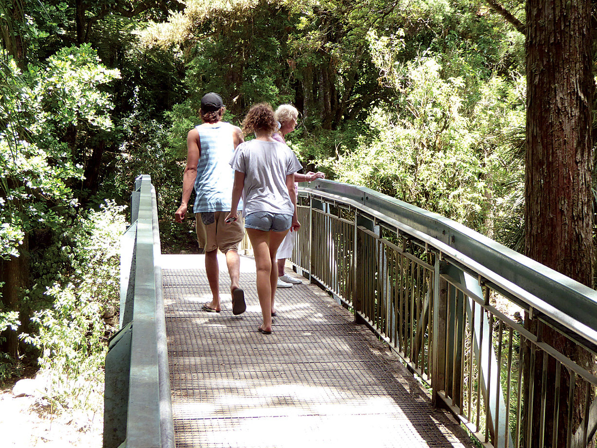
The track splits just a few metres from the carpark. Keep heading straight ahead to do the track in a clockwise direction. At first you follow Waitomo Stream before climbing through tawa forest. Look for the high limestone bluffs to the left of the track. The track then skirts around the edge of a gorge with amazing sculptured rock forms, impressive water chutes and curtains of overhanging vegetation. At the end of this section you can see the downstream entrance to a large tunnel. The stream below can be a peaceful trickle or a more substantial rapid depending on how recent and heavy the last rains were.

At this point the track makes a sharp turn and you sneak through a short limestone passage and travel over the top of the natural tunnel to a track junction. From here  you can turn hard right and return to the car park on the other side of the river or carry on to do the upper loop. If you do the upper loop the track splits again after a few metres.

Heading anticlockwise there is an option of taking a very short side track into the middle of the tunnel with spectacular side-lit views of the river running through the cave system. There are steps down to the viewing point and no lighting so tred carefully.

Back out on the upper circuit there is another short tunnel to go through (just a few metres long with plenty of head-space) and a descent down to the stream. Look for koura and eels in the water if it is clear (the water can be cloudy after rain).

Following the stream you eventually end up at the upstream end of the tunnel. It can be quite disorientating as the stream makes a sharp hidden turn within the tunnel. Climb back up one more set of steps to complete the loop.

On the return track to the carpark there is one more tunnel and a steep descent before a flat finish out to the carpark.

Track information

Time:                45 minutes return

Grade:              Easy (with some short, steep sections)

How to get there

From Waitomo Village head west past the Waitomo Glowworm Caves to a roundabout.  Turn left onto Tumutumu Road and drive for about 3.5 kilometres to the signposted entrance to Ruakuri Scenic Reserve.  The carpark is the meeting  place for visitors to Aranui Cave and the end point for one of the Black Water Rafting trips, as well as being a popular picnic area and the start of the Ruakuri Walk – so it can be a busy place.

Extracted and adapted for Walking New Zealand from: Great Tracks and Trails – Waikato, King Country, Taupō, by Sonia Frimmel


Whangarei Falls – A walk not to be missed

By North Island, Northland Walks, Short Walks

A popular walk in Whangarei, just a few minutes drive from the CBD, is the Whangarei Falls walk.

The walk loops around the waterfall, down one side, crossing a footbridge at the bottom and back up the other side. It has well maintained tracks and is suitable for all ages although both sides of this circular track do zig zag down steep slopes to the lower bridge.

An easy walking path leads to the upper waterfall’s lookout. It takes only two minutes to reach this lookout, and the walk is suitable for people of all abilities. Take the track to the left to the waterfall’s base, cross the river via a concrete bridge and follow the track.

One minute after crossing the river you’ll see one more upper lookout – don’t miss it. It will take five minutes to reach the waterfall’s base from this lookout and then five  minutes to come back to the carpark using the same track, or return via the 30-minutes’ loop track. This track has the stairs and not suitable for wheelchairs/strollers

The picturesque waterfall is 26.3m high and falls over basalt cliffs. The two viewing platforms above the waterfall give spectacular views of the falls and a birds eye view of the forest below.
Don’t be disappointed! Whangarei Falls is a type of waterfalls which may have little or no water at all during a dry summer. Hence, if the summer is dry with no rain for a few weeks, please don’t expect to see a powerful waterfall. There is a lovely picnic area and public toilets by the carpark.

The walk accesses the AH Reed Kauri Park, with 500 year old kauri trees, and is the uppermost section of the complete Hatea River walk.
Enjoy the sights, sounds and smells of native New Zealand bush. Trees include nikau, totara, manuka, to kouka (cabbage tree) and ponga (tree fern) and birds that you may see and hear include kukupa (native wood pigeon), tui and riroriro (grey warbler).

History

Traditionally this area was a good eeling spot for the local Maori and around the turn of the century it was a popular picnic spot (and still is today) for Whangarei residents.
The base of the falls may once have been tapu (sacred) as the pools below the falls were once used for washing the wounded and dead, and was known to Maori as an area of healing.
In the late 1920’s, Mr Archibald Clapham brought the property, reputedly to prevent the falls being developed as a commercial watermill. In 1946 a local businessmen’s association raised the purchase price by public subscription and the property was vested as a public domain in 1958.

Fact file

Whangarei Falls is roughly a 10-minutes’ drive away from Whangarei city center, or 2.5-hours’ from Auckland. The road surface is always sealed.
Make your own way to Whangarei, then follow the signs ‘Whangarei Falls’ until you reach a car park at Boundary Road. The area is very well maintained and has toilets as well as a beautiful picnic area with a few tables.